A detailed version of route (complete with route numbers) we took and a short version listing only the National Park System units is available. If you're travelling cross country, I highly recommend considering some of the points on this route, based on the review below. (The pictures get better as you scroll down.)
Twenty two days, Thirteen states, 32 National Park System units, 6500 miles, two flat tires, and one speeding ticket. That just about begins the description of our cross-country across the U.S., from Washington, DC to Stanford, CA. Add to that the images of some of the most diverse natural wonders one can encounter on this planet: lush green forests, towering mountains and gorgeous valleys, both fir capped and snow capped peaks, badlands, deserts (painted and otherwise), magnificent rock formations such as arches, canyons, and natural bridges, great sand dunes, fossil beds, and beautiful waterfalls. We saw it all, except for the ocean.
The trip began around noon on August 1, 1997 near the Washington, D.C. Cathedral where we left for CARB in Maryland. After saying goodbyes to people I had known for over four years, we headed south into Virginia. Going through Virginia wasn't that eventful, though we did pass through the Shenandoah and Jefferson National Forests. We arrived in Tennessee late evening and stopped just at the intersection of I-81 and and I-40.
The next day, we headed to the 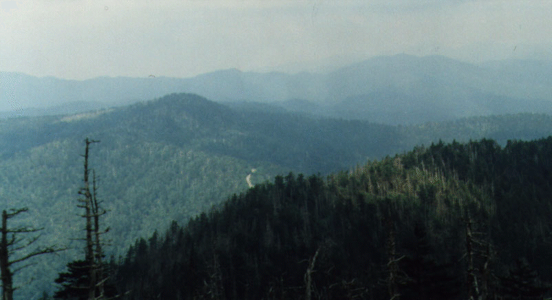 Great Smoky Mountains
National Park, "the majestic climax of the Appalachian Highlands."
I had been here earlier in 1992, as part of a class trip where I spent
hiking the park, learning about the various plants in one of the
world's finest examples of temperate deciduous forests. As we drove
through Gatlinburg, I couldn't help but think how gaudy it had become
(not that it was in a pristine stage to begin with). The park itself
was also quite crowded, but it was much better than the traffic in
Gatlinburg. The Smoky Mountains are so named because because of the
smoke-like haze enveloping the mountains, "which stretch in sweeping
troughs and mighty billows to the horizon." The first thing we did
was climb to the top of Clingman's dome and enjoy the breathtaking
view of the Smokies. We then went down to Alum Cove Buffs where we
did about a 3 mile hike, and proceeded west on I-40.
Great Smoky Mountains
National Park, "the majestic climax of the Appalachian Highlands."
I had been here earlier in 1992, as part of a class trip where I spent
hiking the park, learning about the various plants in one of the
world's finest examples of temperate deciduous forests. As we drove
through Gatlinburg, I couldn't help but think how gaudy it had become
(not that it was in a pristine stage to begin with). The park itself
was also quite crowded, but it was much better than the traffic in
Gatlinburg. The Smoky Mountains are so named because because of the
smoke-like haze enveloping the mountains, "which stretch in sweeping
troughs and mighty billows to the horizon." The first thing we did
was climb to the top of Clingman's dome and enjoy the breathtaking
view of the Smokies. We then went down to Alum Cove Buffs where we
did about a 3 mile hike, and proceeded west on I-40.
After going through Knoxville, and Nashville, we stopped in Memphis and had dinner at the B. B. King Blues Cafe on Beale street. We then checked out what all the hype was about Elvis' Graceland (which isn't much), and began our drive through Arkansas, stopping for the night just after passing Little Rock.
On the Fourth, we arrived at  Hot Springs National
Park. This wasn't one of the highlights of the trip. Essentially
the main feature of this park is the presence of hot thermal springs
whose water is believed by some to have rejuvenating powers. The
water, which is naturally sterile, coming out the springs at a
temperature of 143 degrees F (62 degrees C) was originally percolating
downward after a rainfall. As it reached the warmer rock underneath,
it was heated and flowed back to the surface. We took a short hike to
an observation tower that gave us a great view of the Hot Springs
area, and that was about the only highlight of this stop.
Hot Springs National
Park. This wasn't one of the highlights of the trip. Essentially
the main feature of this park is the presence of hot thermal springs
whose water is believed by some to have rejuvenating powers. The
water, which is naturally sterile, coming out the springs at a
temperature of 143 degrees F (62 degrees C) was originally percolating
downward after a rainfall. As it reached the warmer rock underneath,
it was heated and flowed back to the surface. We took a short hike to
an observation tower that gave us a great view of the Hot Springs
area, and that was about the only highlight of this stop.
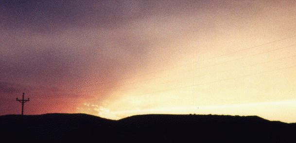
After leaving Hot Springs, we went up north on SR 7, cutting through the beautiful Ouachita National Forest before we ran into I-40. The next day (August Fifth), we went clear through Oklahoma, stopping to get an oil change in Oklahoma city, without any real surprises. We stopped for the night in the panhandle of Texas, in Amarillo.
The real beginning of our trip was heralded by stormy weather. As
we went north from Amarillo to Alibates National Monument, we
encountered torrential rain which made it hard to see more than three
feet ahead of you. It was quite an existential experience. When we
finally made it to Alibates flint quarries, we found out the that the
quarry trips were cancelled due to the weather. Which is just as well,
as the most interesting part of this monument is the beautiful scenery
around the flint quarries, which is part of the Lake Meredith National
Recreation Area. By the time we were on the 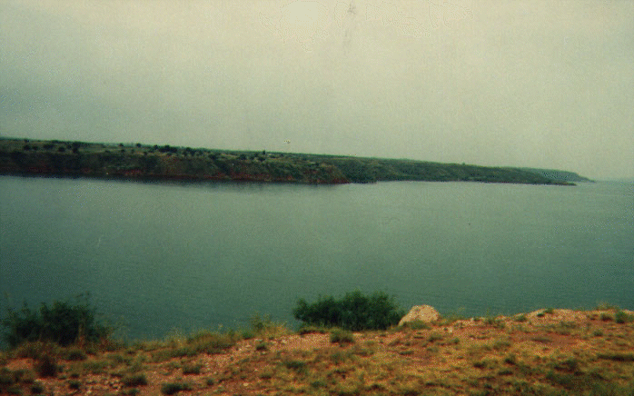 banks of Lake
Meredith, the sun was beginning to shine through and we thought
we'd have better luck at the next monument, but it wasn't to be.
banks of Lake
Meredith, the sun was beginning to shine through and we thought
we'd have better luck at the next monument, but it wasn't to be.
Capulin Mountain National Monument in New Mexico is basically centred around the Capulin Volcano (which was active only 62,000 years ago, and represents the last stage of a great period of volcanism that had begun about eight million years earlier). Normally, one can drive to the top of the volcano, but since the weather was so foggy around the top, we weren't permitted to do that. After waiting for a bit, we decided to move onto to the next monument with a promise to come back some day.
The next day (August 7), we were up bright and early and headed
out to the  Great Sand
Dunes National Monument in Colorado. This was one of the biggest
highlights of our trip. The weather wasn't too hot, nor too cold,
which made walking on the sand a pleasant experience. The sun wasn't
always shining, but it was for the best: the hike to the top of the
dunes (where you can see the real dunes) was about four miles
round trip. And hiking through sand up hill is a nontrivial
experience. But it was worth it: the views were spectacular. I had
never seen anything like it before: Huge sand dunes in the middle of a
valley (San Luis) enveloped by forests and mountain ranges (Sangre de
Cristo and San Juan), with a huge river (the Rio Grande) flowing right
by.
Great Sand
Dunes National Monument in Colorado. This was one of the biggest
highlights of our trip. The weather wasn't too hot, nor too cold,
which made walking on the sand a pleasant experience. The sun wasn't
always shining, but it was for the best: the hike to the top of the
dunes (where you can see the real dunes) was about four miles
round trip. And hiking through sand up hill is a nontrivial
experience. But it was worth it: the views were spectacular. I had
never seen anything like it before: Huge sand dunes in the middle of a
valley (San Luis) enveloped by forests and mountain ranges (Sangre de
Cristo and San Juan), with a huge river (the Rio Grande) flowing right
by.
Although the dunes seem a bit out of place, they key conditions for creating them (sand, wind, and time) exist here. The Rio Grande meandering through the San Luis valley deposited eroded bits of the 14,000 foot Sangre de Cristo and San Juan mountain ranges on its banks. The deposits of sand were exposed to the winds that swept across the valley, which pushed and coaxed the grain of sand northeast, until it ran across the steep Sangre de Cristo mountains. While the wind was able to rise up or go through the mountain (via passes), the heaviest sand stayed put. Over thousands of years, this led to the creation of the Great Sand Dunes.
Coming back down the Great Sand Dunes was really easy. One could just let the momentum due to gravity take you through and this took an extremely short time, relative to the climb up. If you ever make it to Colorado, this is one of those parks that should not be missed (you'll find Colorado has a lot of these).
We had enough time left in the day to get to  Florissant Beds
National Monument, going through Pike National Forest. The
Monument is basically a collection of Fossilised Flower Beds, created
as a result of volcanic eruptions 34 million years ago. The main
feature of this park were massive
Florissant Beds
National Monument, going through Pike National Forest. The
Monument is basically a collection of Fossilised Flower Beds, created
as a result of volcanic eruptions 34 million years ago. The main
feature of this park were massive 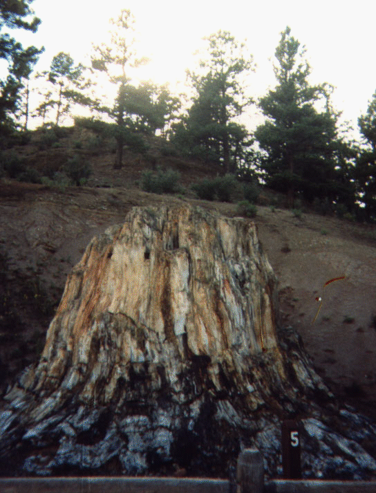 petrified redwood
stumps. We then drove through Colorado Springs and Denver and
stopped for the night in a smelly town called Greeley.
petrified redwood
stumps. We then drove through Colorado Springs and Denver and
stopped for the night in a smelly town called Greeley.
The next stop, on August 8, was the 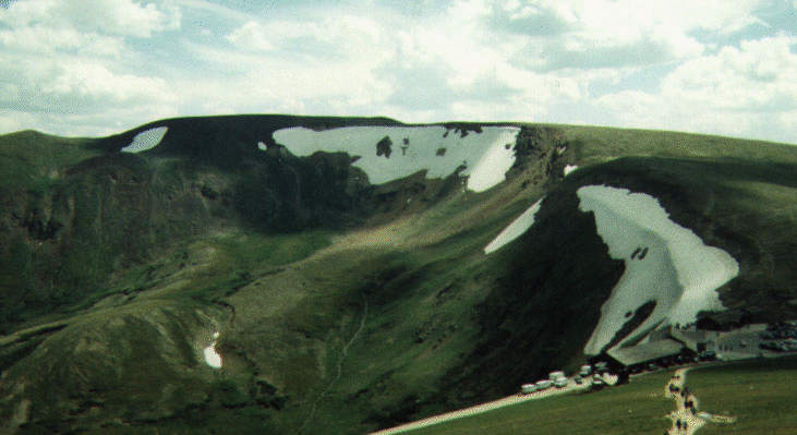 snow-mantled Rocky
Mountain National Park, another highlight of the trip. We spent a
full day in the,
snow-mantled Rocky
Mountain National Park, another highlight of the trip. We spent a
full day in the, 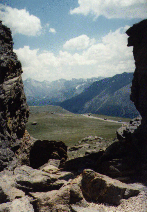 hiking to Rock
Cut, Fall River Pass, and
hiking to Rock
Cut, Fall River Pass, and 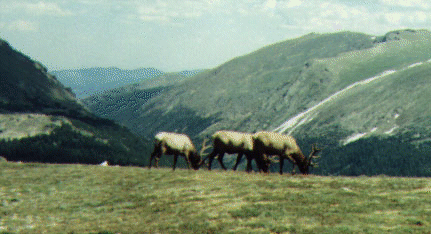 Milner Pass. Mere
words can't describe the views I saw, and so I'll let the pictures do
the talking here. Suffice to say that this is a must-do experience
for any mountain lover. We left the park passing through Arapaho and
Routt National Forests.
Milner Pass. Mere
words can't describe the views I saw, and so I'll let the pictures do
the talking here. Suffice to say that this is a must-do experience
for any mountain lover. We left the park passing through Arapaho and
Routt National Forests.
I got my first speeding ticket, given by a Routt National Forest Park Ranger, to boot! While I think Park Rangers in general do a good service (I'm indebted to at least one; see Walnut Canyon National Monument below), I think a lot of their time could be put to better use than waiting in speed traps for unsuspecting tourists. Essentially the situation in any of these mountainous parks or forests is that even though the speed limit may be high (in my case, 65 MPH), you have a long uphill and downhill stretches. Unless you have a reasonably powerful vehicle, most will slow down during the uphill climb, and assuming the same momentum exists, will go down fast during the downhill climb, sometimes going over the speed limit. Well, this is exactly what the Park Rangers look for (which I realised as soon as I saw other cars pulled over right before I was asked to be pulled over). Mind you, this was no isolated incident. Throughout the trip, in similar situations, we saw Park Rangers preying on vehicles going down hill. The interesting thing is that none of this serves as a deterrent in any way; while I was being pulled over, or when I saw someone pulled over, people shot down the hill the same way. All it does is increase revenue, which isn't a bad thing in and of itself, but I think better means could be adopted.
But I digress. My detailed views on these sorts of illogical acts can be found elsewhere. I consider a speeding ticket to be a badge of honour for driving in this country and I wasn't going to let it interfere with my vacation. So I immediately paid the fine, with the hope that at least some revenue went to preserving the forests I had just been through, and headed off towards Dinosaur National Monument, just outside the Colorado border, in Utah.
 Dinosaur National
Monument is so named because it is a quarry where large numbers of
Dinosaur fossils have been excavated. The more interesting portion of
this park is really in the area (in the Colorado side) where there are
no dinosaur fossils. These feature beautiful canyons and gorges.
Dinosaur National
Monument is so named because it is a quarry where large numbers of
Dinosaur fossils have been excavated. The more interesting portion of
this park is really in the area (in the Colorado side) where there are
no dinosaur fossils. These feature beautiful canyons and gorges.
After Dinosaur National Monument, we headed south to the 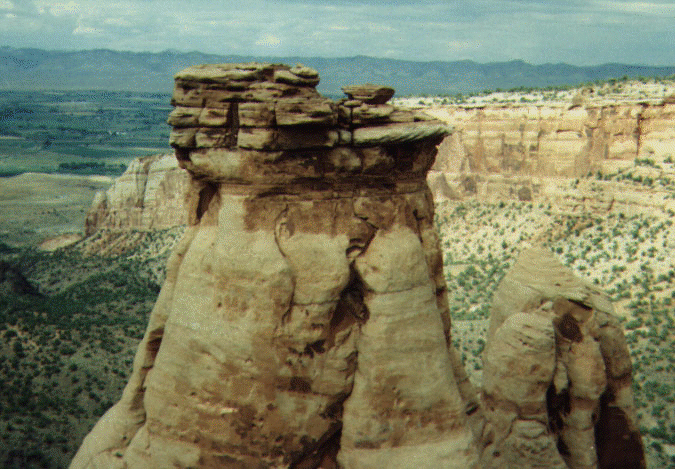 Colorado National
Monument (back again in Colorado), which is once again a "don't
miss" place. The main feature of this monument is "bold, big, and
brilliantly coloured" towering masses of naturally sculpted rock
formations, plateaus, and canyons.
Colorado National
Monument (back again in Colorado), which is once again a "don't
miss" place. The main feature of this monument is "bold, big, and
brilliantly coloured" towering masses of naturally sculpted rock
formations, plateaus, and canyons.
Once we finished experiencing Colorado National Monument, we had
dinner in Grand Junction, and went back to Utah and stopped for the
night in a Moab. On August 10, we headed out the 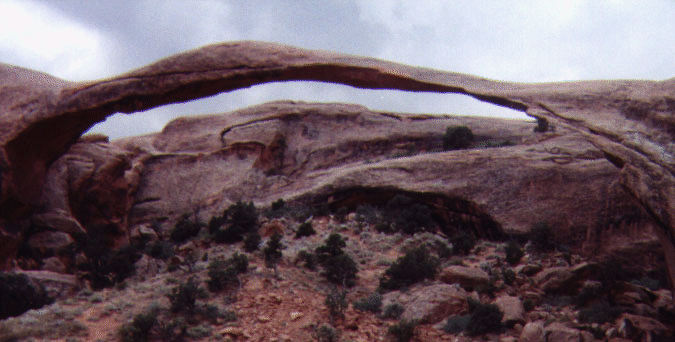 Arches
National Park. This is a park with a particular type of rock
formation, arches, which are caused by wind erosion. Arches National
Park, features, in a highly localised region, some of the most
spectacular arches I've ever seen. Some of these arches have
appropriate names, such as Delicate Arch and
Arches
National Park. This is a park with a particular type of rock
formation, arches, which are caused by wind erosion. Arches National
Park, features, in a highly localised region, some of the most
spectacular arches I've ever seen. Some of these arches have
appropriate names, such as Delicate Arch and 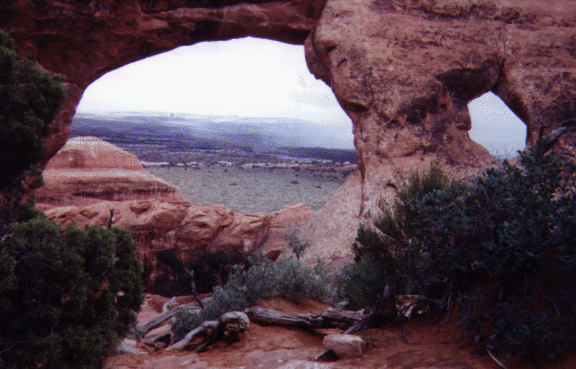 Turret Arch
and some don't (I think
Turret Arch
and some don't (I think 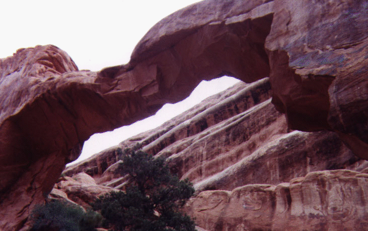 Wall Arch should be
called Basket Handle Arch). I personally recommend the hike of at
least up to Double O Arch in the Devil's Garden section (which is
about 5 miles round trip), and to Delicate Arch (about 3 miles round
trip).
Wall Arch should be
called Basket Handle Arch). I personally recommend the hike of at
least up to Double O Arch in the Devil's Garden section (which is
about 5 miles round trip), and to Delicate Arch (about 3 miles round
trip).
The reason for the localisation of the arches is because the park lies atop an underground salt bed, which, combined with wind erosion, results in arches, spires, balancing rocks, sandstone fins, and eroded monoliths. In fact, the entire area surrounding Moab is similar, but less glamorous.
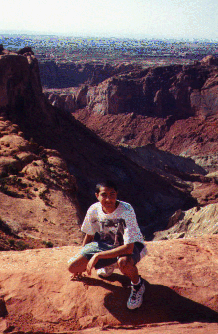
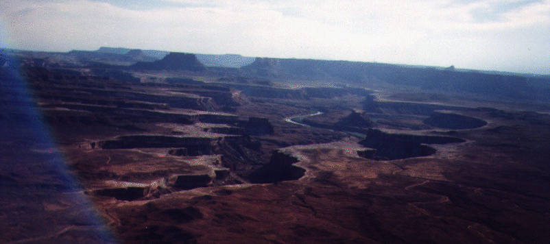 Canyonlands
National Park is right next door to Arches National Park (at least
the Island in the Sky district is). The Island in the Sky is a huge
mesa that leads to the edge of the canyon through which the Green and
Colorado rivers flow. I recommend hiking to
Canyonlands
National Park is right next door to Arches National Park (at least
the Island in the Sky district is). The Island in the Sky is a huge
mesa that leads to the edge of the canyon through which the Green and
Colorado rivers flow. I recommend hiking to 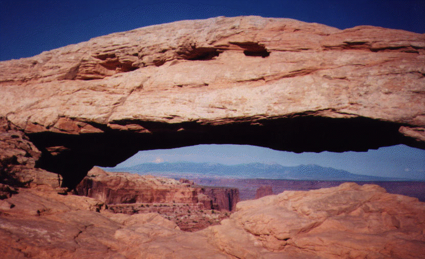 Mesa Arch which
offers a great view through the arch hole, and to the Green River
overlook, which gives a great view of the Green River. The canyons in
Canyonlands mask the confluence of the Green and Colorado
rivers. I wasn't able to make it all the way down to see it happen,
but it must be a spectacular sight from the pictures I've seen:
imagine two huge rivers, one brown, and one green, mixing
together. Which colour will win?
Mesa Arch which
offers a great view through the arch hole, and to the Green River
overlook, which gives a great view of the Green River. The canyons in
Canyonlands mask the confluence of the Green and Colorado
rivers. I wasn't able to make it all the way down to see it happen,
but it must be a spectacular sight from the pictures I've seen:
imagine two huge rivers, one brown, and one green, mixing
together. Which colour will win?
We stopped for the night in Monticello, and went to the Natural Bridges National Monument on August 11. Not a lot to see here---three natural bridges (Owachomo, Sipapu, and Kachina) caused by water erosion. Not to take away from their beauty, but after the experiences at the Arches and Canyonlands parks, the natural bridges were bit of an anti-climax.
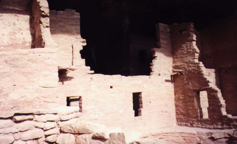
The next stop was 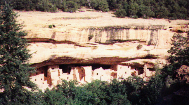 Mesa Verde
National Park, which features ancient Indian cliff dwellings,
constructed by the Mesa Verde Anasazi Indians about 1400 years
ago. This is a rather "mainstream" park in terms of Indian ruins, and
you could take trips down the kiwis and the like.
Mesa Verde
National Park, which features ancient Indian cliff dwellings,
constructed by the Mesa Verde Anasazi Indians about 1400 years
ago. This is a rather "mainstream" park in terms of Indian ruins, and
you could take trips down the kiwis and the like.
We stopped for the night in Cortez, and the next day we woke up to
a flat tire. It was fortunately repaired by the local Big-O Tires. We
then pressed on, going through the Four Corners Monument (the only
point in the U.S. where four states, Arizona, Colorado, New Mexico,
and Utah, meet) before we stopped at the 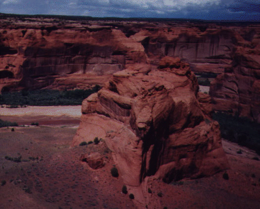 Canyon De Chelley
National Monument in Arizona. Canyon De Chelley is similar to Mesa
Verde, but is more picturesque. Like with Dinosaur National Monument,
it is the natural scenery in the monument that is more attractive than
the monument itself. We took the South Rim Drive, seeing the White
House ruins, along with some great views of the canyon. As we headed
south once more. We stopped for a few seconds at the Hubbell Trading
Post National Historical Site (to commemorate John Hubbell, a trader
who gave counsel to the Indians) and finally arrived at the Petrified
National Forest on the afternoon of 12th.
Canyon De Chelley
National Monument in Arizona. Canyon De Chelley is similar to Mesa
Verde, but is more picturesque. Like with Dinosaur National Monument,
it is the natural scenery in the monument that is more attractive than
the monument itself. We took the South Rim Drive, seeing the White
House ruins, along with some great views of the canyon. As we headed
south once more. We stopped for a few seconds at the Hubbell Trading
Post National Historical Site (to commemorate John Hubbell, a trader
who gave counsel to the Indians) and finally arrived at the Petrified
National Forest on the afternoon of 12th.
We though we'd have only three hours to see the Petrified forest,
but it turned out that a lot of Arizona was on Daylight Savings Time,
which meant that we had an extra hour to spare. The first sight we
encountered was the 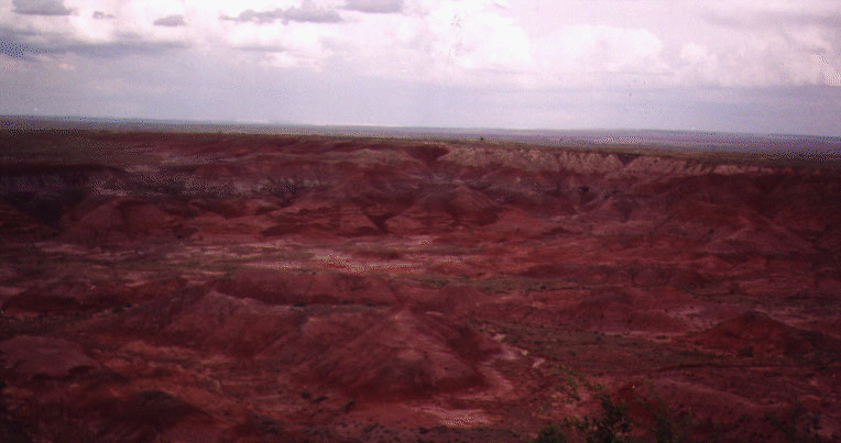 painted
desert. I took a hike through
painted
desert. I took a hike through 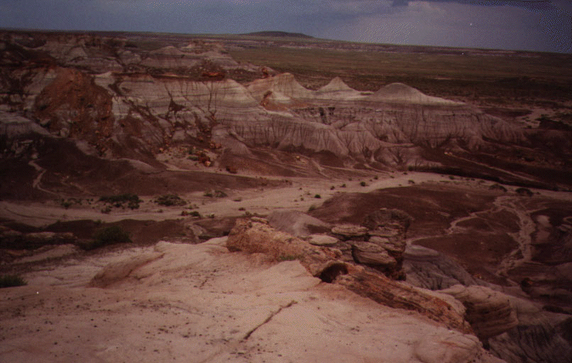 the badlands
where I got see some petrified wood (created by the encasing of wood
tissue with silica deposits) close up.
the badlands
where I got see some petrified wood (created by the encasing of wood
tissue with silica deposits) close up.
August 13 was a busy day: we managed to go through five sights in
one day. The first stop was at 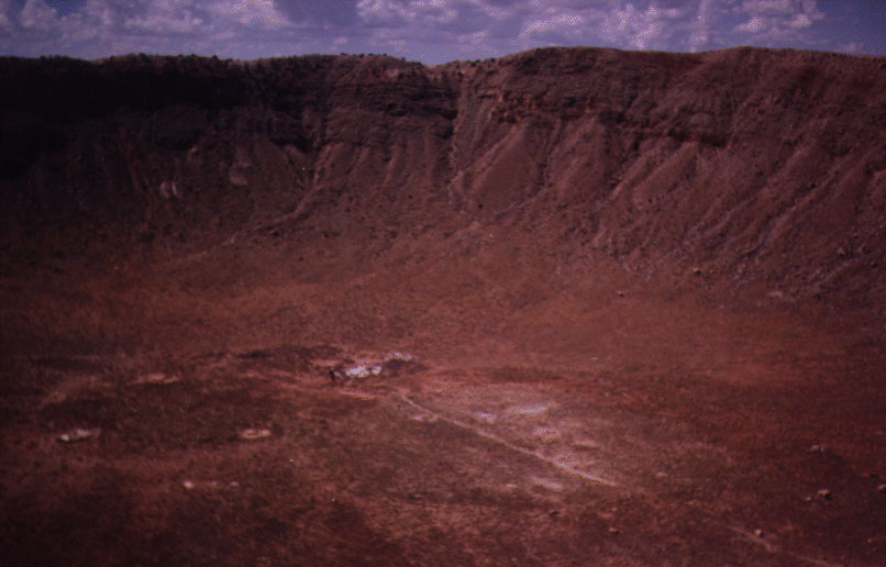 the Meteor
Crater, which isn't a national park and charged exorbitant
entrance fees. The meteor crater in Arizona is a huge crater (570 feet
deep, and a mile across) believed to have been caused by a meteorite
some 49,000 years ago. I recommend it if you're not on a tight
budget, but otherwise it's not worth it. The next stop was Walnut
Canyon National Monument, home to Sinagua Indians who lived here more
than 800 years ago. I managed, in my infinite wisdom, to leave the
car keys in the car as we got out. Fortunately, a Park Ranger (first
name was Mary) was able to pop the lock open and we were able to move
on to Sunset Crater National Monument, heading north on SR 89. Sunset
Crater is an extinct volcano (which last erupted only about 1000 years
ago), with a 1000 foot cinder volcanic cone. One of the striking
features is the huge amount of lava flow that still exists that you
can walk through. Right past Sunset Crater is Wupatki National
Monument, which contains Sinaguan and Anasazi Indian ruins.
the Meteor
Crater, which isn't a national park and charged exorbitant
entrance fees. The meteor crater in Arizona is a huge crater (570 feet
deep, and a mile across) believed to have been caused by a meteorite
some 49,000 years ago. I recommend it if you're not on a tight
budget, but otherwise it's not worth it. The next stop was Walnut
Canyon National Monument, home to Sinagua Indians who lived here more
than 800 years ago. I managed, in my infinite wisdom, to leave the
car keys in the car as we got out. Fortunately, a Park Ranger (first
name was Mary) was able to pop the lock open and we were able to move
on to Sunset Crater National Monument, heading north on SR 89. Sunset
Crater is an extinct volcano (which last erupted only about 1000 years
ago), with a 1000 foot cinder volcanic cone. One of the striking
features is the huge amount of lava flow that still exists that you
can walk through. Right past Sunset Crater is Wupatki National
Monument, which contains Sinaguan and Anasazi Indian ruins.
We then headed south, passing through Flagstaff, to 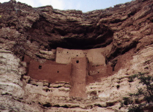 Montezuma Castle
National Monument. While making long detours for one-sight
monuments isn't something I advise, Montezuma castle, built by Sinagua
farmers, is definitely worth it. A short distance away from Montezuma
Castle National Monument was Tuzigoot (Apache for "crooked water")
National Monument, which features the remnant of a Sinaguan village
built around 1000 years ago, and we decided to go through there as
well. Once again, the daylight savings time worked in our
favour.
Montezuma Castle
National Monument. While making long detours for one-sight
monuments isn't something I advise, Montezuma castle, built by Sinagua
farmers, is definitely worth it. A short distance away from Montezuma
Castle National Monument was Tuzigoot (Apache for "crooked water")
National Monument, which features the remnant of a Sinaguan village
built around 1000 years ago, and we decided to go through there as
well. Once again, the daylight savings time worked in our
favour.
We stopped for the night in Flagstaff. On August 14, we were at
the 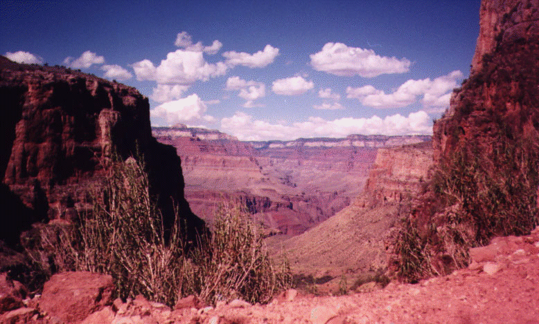 Grand Canyon National
Park. By the time we got through the traffic, it was around noon,
right when the sun was really going to be hot. I decided to hike down
the Bright Angel (an elevation of 2091 metres) trail. It was planning
only on going the three mile point. Since it was all downhill, I made
it there in about a 45 minutes and decided to continue on. I was at
Indian Gardens in an hour, and I kept going, and before I knew it, I
was at Plateau Point (an elevation of 1146 metres), 6.1 miles from the
rim,
Grand Canyon National
Park. By the time we got through the traffic, it was around noon,
right when the sun was really going to be hot. I decided to hike down
the Bright Angel (an elevation of 2091 metres) trail. It was planning
only on going the three mile point. Since it was all downhill, I made
it there in about a 45 minutes and decided to continue on. I was at
Indian Gardens in an hour, and I kept going, and before I knew it, I
was at Plateau Point (an elevation of 1146 metres), 6.1 miles from the
rim,  looking down at the
Colorado River. It was a magnificent sight. After taking in the
view for a bit, I headed back.
looking down at the
Colorado River. It was a magnificent sight. After taking in the
view for a bit, I headed back.
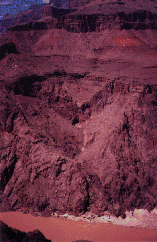
The climb back up was a lot more taxing. I spent almost four hours climbing up. The total distance was 12.2 miles round trip, and the elevation change was 945 metres (or 3100 feet). Still, the total time I took (6 hours), in the hottest part of the day (between 12p and 6p), was two hours shorter than the lower limit for this hike (of 8 hours). This was the maximum recommended hike, and the Canyon Guide says "under no circumstances should you attempt to hike from the rim to the river and back in one day." But I think if you leave early enough, you can easily do it with a few hours to spare.
Hiking down the Grand Canyon is taxing. The combination of the heat and the ascent really taxes you even if you have a lot of stamina. I was sore the next couple of days. A most existential experience indeed.
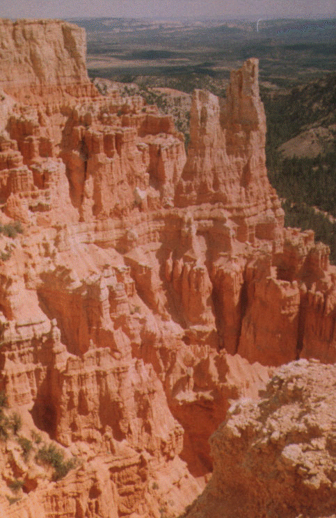 Bryce Canyon, back
in Utah, was far more spectacular than the Grand Canyon. I took a
short (1.6 mile round trip) hike in the Navajo loop trail and
encountered amazing sights:
Bryce Canyon, back
in Utah, was far more spectacular than the Grand Canyon. I took a
short (1.6 mile round trip) hike in the Navajo loop trail and
encountered amazing sights: 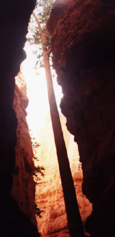 trees growing at
the base reaching for the sun and beautifully sculpted rock
formations known as
trees growing at
the base reaching for the sun and beautifully sculpted rock
formations known as 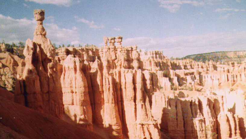 "hoodoos".
This was yet another highlight in the trip. The "Hoodoos" were formed
by the hardening of ancient sedimentation of a great seaway that
extend into the area that is Bryce Canyon today. Deformation and
uplift of these sediments due to movements further north-east in the
Rockies, and differential erosion lead to the formation of vertical
columns of these sedimented rock. Nature couldn't have a developed a
better sculptor through design.
"hoodoos".
This was yet another highlight in the trip. The "Hoodoos" were formed
by the hardening of ancient sedimentation of a great seaway that
extend into the area that is Bryce Canyon today. Deformation and
uplift of these sediments due to movements further north-east in the
Rockies, and differential erosion lead to the formation of vertical
columns of these sedimented rock. Nature couldn't have a developed a
better sculptor through design.
 Capitol Reef
National Monument was next. The reef is so named because of rock
formations that resemble the U.S. Capitol and the Great Barrier
Reef. While I think the reef part, is okay, the comparison to the
U.S. Capitol is exaggerating things a bit: even Capitol Dome doesn't
live to up to its description. But again, this was a place with great
rock formations, especially the Waterpocket fold, "a giant, sinuous
wrinkle in the Earth's crust, created by the same tremendous forces
that built the Colorado Plateau 65 million years ago. The park
"preserves the old and its spectacular eroded jumble of colourful
cliffs, massive domes, soaring spires, stark monoliths, twisting
canyons, and graceful arches."
Capitol Reef
National Monument was next. The reef is so named because of rock
formations that resemble the U.S. Capitol and the Great Barrier
Reef. While I think the reef part, is okay, the comparison to the
U.S. Capitol is exaggerating things a bit: even Capitol Dome doesn't
live to up to its description. But again, this was a place with great
rock formations, especially the Waterpocket fold, "a giant, sinuous
wrinkle in the Earth's crust, created by the same tremendous forces
that built the Colorado Plateau 65 million years ago. The park
"preserves the old and its spectacular eroded jumble of colourful
cliffs, massive domes, soaring spires, stark monoliths, twisting
canyons, and graceful arches."
On August 17, we headed to 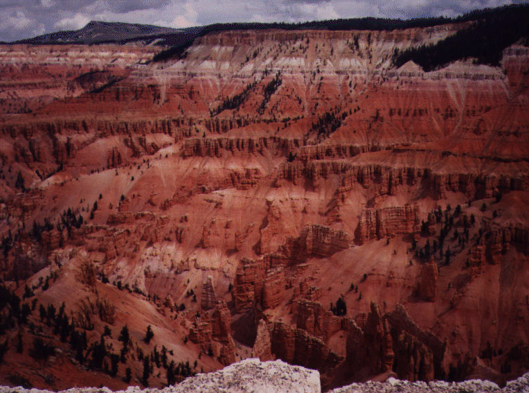 Cedar Breaks, a
great natural rock amphitheatre, "a spectacle of gigantic dimensions
full of extraordinary forms wrapped in bold and brilliant colours."
This is similar to Bryce Canyon, but is smaller in terms of area,
though all the features are concentrated in a coliseum-like shape that
is more than 2,000 feet deep and 3 miles in diametre. The intricate
formations in the rock is definitely worth a visit.
Cedar Breaks, a
great natural rock amphitheatre, "a spectacle of gigantic dimensions
full of extraordinary forms wrapped in bold and brilliant colours."
This is similar to Bryce Canyon, but is smaller in terms of area,
though all the features are concentrated in a coliseum-like shape that
is more than 2,000 feet deep and 3 miles in diametre. The intricate
formations in the rock is definitely worth a visit.
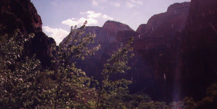 Zion National Park
was impressive. It's a serene sort of place, and unlike many other
parks with huge canyons, this is teeming with life and greenery. The
hanging gardens could be right out of an ancient religious setting. I
did a couple of hikes here to the Emerald Pools and ventured in the
Narrows a bit, but I generally don't recommend it unless you have
time. I think it's better to just pick a particular spot and relax
and take in the natural beauty.
Zion National Park
was impressive. It's a serene sort of place, and unlike many other
parks with huge canyons, this is teeming with life and greenery. The
hanging gardens could be right out of an ancient religious setting. I
did a couple of hikes here to the Emerald Pools and ventured in the
Narrows a bit, but I generally don't recommend it unless you have
time. I think it's better to just pick a particular spot and relax
and take in the natural beauty.
After Zion, we headed back to Arizona, to make a brief stop at the Pipe Springs National Monument (a memorial to the early cattle ranches and cowboys). From there, we headed to Las Vegas, where we spent two days (August 18-19) and I ended up losing a bit of money.
When we arrived in  Las Vegas, we
stayed for the night in Circus Circus, which is one of the worst
establishments I've been in. This was a place where the management
had no clue what was happening. As a result, the place was a mess, in
total confusion. Fortunately, the next night we stayed in Westward
Ho. While the rooms weren't as nice, the service was definitely
better. I recommend avoiding Circus Circus at all costs.
Las Vegas, we
stayed for the night in Circus Circus, which is one of the worst
establishments I've been in. This was a place where the management
had no clue what was happening. As a result, the place was a mess, in
total confusion. Fortunately, the next night we stayed in Westward
Ho. While the rooms weren't as nice, the service was definitely
better. I recommend avoiding Circus Circus at all costs.
Anyhow, after the first night, I had this brilliant idea to beat the system. Essentially, find a game where the chances of you winning is 0.5, and then bet incrementally. That is, begin the betting with, say, $2.00. If you win, great. Put the $2.00 aside in your winning pile. If you lose, then bet $4.00. And so on, until you win once. Every time you win, you re-start this process, but you'll be $2.00 ahead always. After playing 50 such trials, you'll be $100.00 ahead.
Well, this is a nice system in theory. In practice, there are a few problems. One, you need to watch the game carefully to make sure there is indeed a 0.5 chance. I tried this first at Blackjack, and some saloons give you a better shot (I presume this had to do with the deck of cards used) than others. Roulette was the next thing I tried, and I was generally successful here. The second thing is that you need the capital to take it all the way. This was one of my primary problems. If you lose seven times in a row, then you had to have a total of $510 to begin with to continue for the 8th try. Third, you need to be wary of table limits, though some of the casinos have reasonable limits and you can indeed take it this far. Finally, you should quit when you're ahead.
I myself didn't follow these instructions, and as a result, I lost a bit, but I will remember till the day I die that Las Vegas owes me money, and I'll definitely be back to get it.
We left Las Vegas on August 20 and headed into California and went
through Death Valley National
Park, a place I had visited last winter. We arrived a bit late in
the evening, 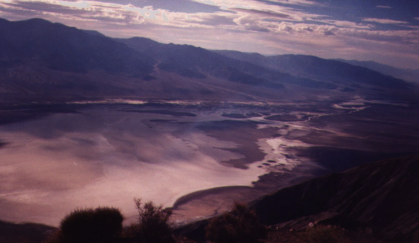 getting a
great view from Dante's Peak, but the temperature at Bad Water was
still around 120 degrees Fahrenheit (almost 50 degrees
Centigrade). From those temperatures, it may seem obvious why the
place is called Death Valley, but in reality, Death Valley's
reputation unfortunately overtakes the fact that it has a tremendous
of scenic beauty that is teeming with life. We spent the night in the
park, and went up to Devil's Postpile National Monument, after passing
through the Mananzar National Historical Site (where Japanese
Americans were quartered during World War II).
getting a
great view from Dante's Peak, but the temperature at Bad Water was
still around 120 degrees Fahrenheit (almost 50 degrees
Centigrade). From those temperatures, it may seem obvious why the
place is called Death Valley, but in reality, Death Valley's
reputation unfortunately overtakes the fact that it has a tremendous
of scenic beauty that is teeming with life. We spent the night in the
park, and went up to Devil's Postpile National Monument, after passing
through the Mananzar National Historical Site (where Japanese
Americans were quartered during World War II).
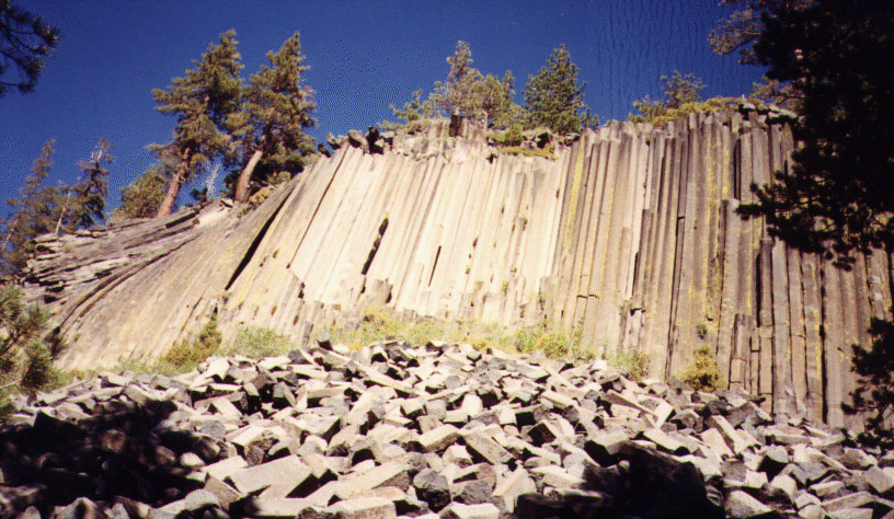 Devil's
Postpile National Monument also offers a stunning view of a
interesting rock formation caused by the cooling and cracking of
basalt lava flow from volcanic vents. Sometimes, the lava cools to
form huge columns (60 feet high, the Devil's Postpile), with
incredibly uniform shapes. It's worth climbing to the top of the
Postpile to see exactly the geometry of the columns.
Devil's
Postpile National Monument also offers a stunning view of a
interesting rock formation caused by the cooling and cracking of
basalt lava flow from volcanic vents. Sometimes, the lava cools to
form huge columns (60 feet high, the Devil's Postpile), with
incredibly uniform shapes. It's worth climbing to the top of the
Postpile to see exactly the geometry of the columns.
For the evening we headed out to 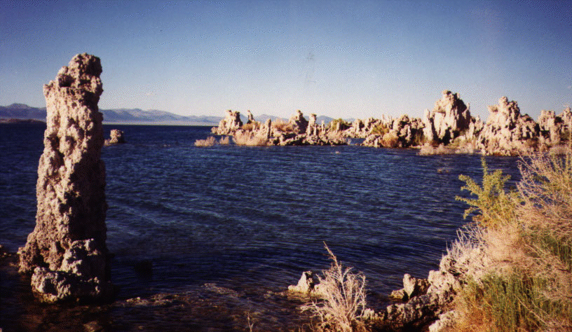 Mono Lake,
where we stayed for the night. Mono Lake looks more attractive in
pictures than it does in real life, but it is still an amazing
sight. The water is peppered with calcium carbonate formations known
as "tufa" which results from the combination of salty lake water
(carbonates) and freshwater springs (calcium). The tufas are as old
as 13,000 years. The lake is surrounded by remnants of volcanic
activity including a volcanic crater that erupted only 600 years ago.
This area definitely deserves to be made into a National Park.
Mono Lake,
where we stayed for the night. Mono Lake looks more attractive in
pictures than it does in real life, but it is still an amazing
sight. The water is peppered with calcium carbonate formations known
as "tufa" which results from the combination of salty lake water
(carbonates) and freshwater springs (calcium). The tufas are as old
as 13,000 years. The lake is surrounded by remnants of volcanic
activity including a volcanic crater that erupted only 600 years ago.
This area definitely deserves to be made into a National Park.
Our final National Park stop was 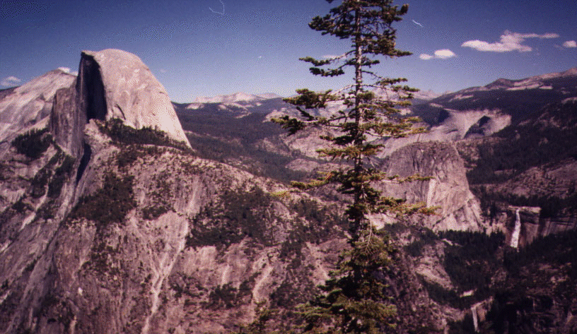 Yosemite, on
August 22, which was one of the most crowded parks I went to. The last time I came here, it
was in the middle of winter, and things were much quieter then. The
summer however allowed us to go through Yosemite via Tioga pass. This
was definitely the best part of the park, because it was less crowded
than Yosemite valley (where thousands of cars were present) and also
because the scenery in this area, especially Tuolumne meadows, are
breathtakingly serene. As we went to the valley, I encountered
familiar sights such as
Yosemite, on
August 22, which was one of the most crowded parks I went to. The last time I came here, it
was in the middle of winter, and things were much quieter then. The
summer however allowed us to go through Yosemite via Tioga pass. This
was definitely the best part of the park, because it was less crowded
than Yosemite valley (where thousands of cars were present) and also
because the scenery in this area, especially Tuolumne meadows, are
breathtakingly serene. As we went to the valley, I encountered
familiar sights such as 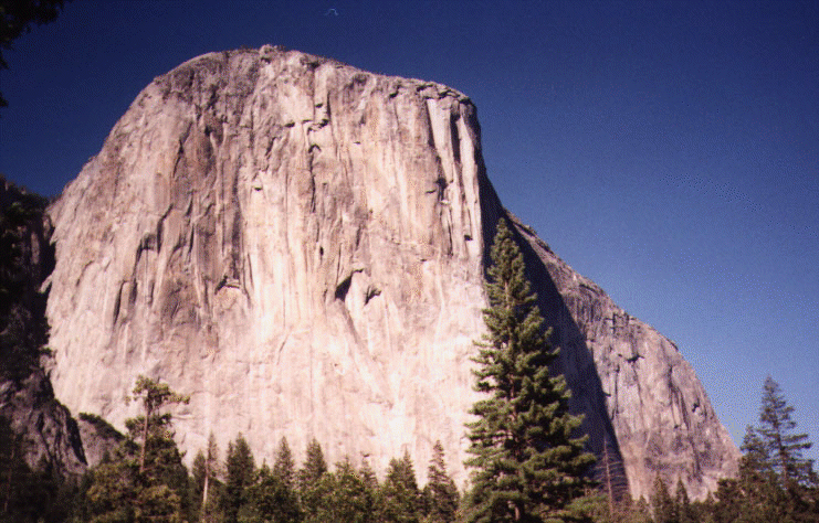 El Capitan,
Half Dome, Bridal Veil falls, Upper and
El Capitan,
Half Dome, Bridal Veil falls, Upper and 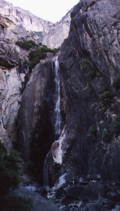 Lower Yosemite
falls, and more. This time we drove to Glacier Point and got a
glimpse of the vast scenery, looking down at the Yosemite valley and
across it, the Yosemite falls.
Lower Yosemite
falls, and more. This time we drove to Glacier Point and got a
glimpse of the vast scenery, looking down at the Yosemite valley and
across it, the Yosemite falls.
A word about park admission fees: I don't think the admission prices charged by any park is unreasonable, however I had a Golden Eagle pass which saved me more than $150 worth of admission fees.
Finally, on the morning of 23rd, we arrived at 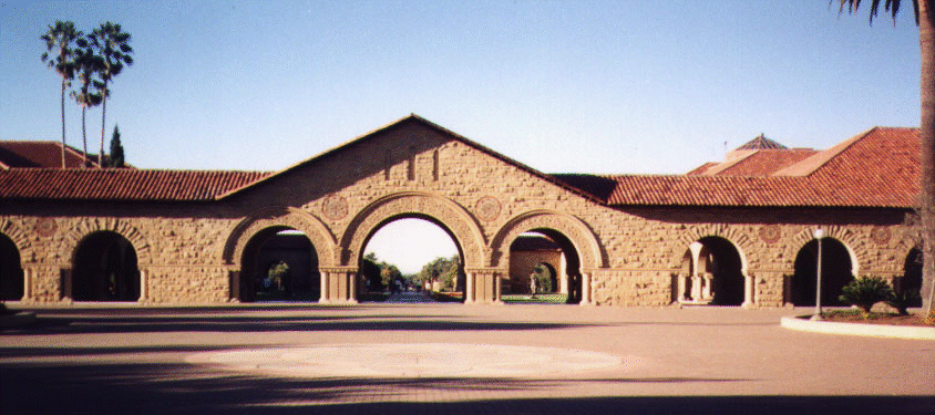 Stanford. It was
a Saturday and the doors were locked, but fortunately I was able to
sneak in, use a computer, find an apartment by searching on the web,
apply it for that day, and by Monday (August 25th) we were allowed to
move in. It's November 22th as I write this, and I still have not
caught up with everything, but I would do the same thing over without
hesitation.
Stanford. It was
a Saturday and the doors were locked, but fortunately I was able to
sneak in, use a computer, find an apartment by searching on the web,
apply it for that day, and by Monday (August 25th) we were allowed to
move in. It's November 22th as I write this, and I still have not
caught up with everything, but I would do the same thing over without
hesitation.